 The layout of every town and village in Huntingdonshire is a historical document that can tell us about the past, just like the manuscripts in the Huntingdonshire Archives. That's more true of Godmanchester than anywhere else in the county.
As well as the medieval parish churches that survive in almost every Huntingdonshire community, the most common relics of the Middle Ages are the "Reverse-S" curves of old streets and property boundaries. Medieval farmers ploughed their land in long strips, banking the soil up in the centre of each strip to make them drain better. The resulting "ridge and furrow" can still be seen in many places, especially where old plough land has been put under grass. You can see some nice examples along the road to Offord.
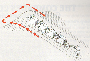
A distinctive feature of the ridges is that they curve to the left at each end, as the plough team of oxen began their turn at the end of the strip. The curve at each end gives the ridges an unmistakable double curve, like backwards "S". Even when the old field system was replaced in the 19th century the new field boundaries often followed the reverse-S curves of the fields that had been there before, and the same is true of roads laid out alongside the fields.
There are some lovely examples in Godmanchester. The property boundaries on both sides of West Street and of Post Street are long rows of these curves, each one the standard 220 yards long-a furlong or "furrow long". Still more can be seen between Earning Street and Tudor Road, where the fields bought by property developers for their new housing estates had reverse-S curves in their boundaries. The hedge line that goes from the end of Peate Close to Earning Street is a classic example and another one runs across the end of York Close.
Watch out when you're walking round town or driving through the countryside - these curves are everywhere. Spotting them can be quite addictive!
All this is true for every town and village in the area but of course Godmanchester has an older layer of history too. The walls of the Roman town survived long enough to influence the lines of streets and boundaries in the modern town.
Earning Street follows the town wall on the east side of the Roman town - the bend in the street is on the site of one of the corners in the hexagonal circuit of the walls. A turret would have stood here 1800 years ago and another corner with another turret underlies the little block of buildings on the corner of West Street and the Causeway.
Bob Burn-Murdoch. Norris Museum St Ives.